Day Five
Friday, 09-03-04
Maintenance day for Big Red. Paul was up and gone by 6:00 a.m. He had to rise so early because even though the Yamaha dealer wasn't open until 8:00 a.m. the bike had to cool sufficiently in order to be worked on.
I slept in. The morning was a fog of recovery. I was really glad for the shower time and the soft bed. Initially we had planned to camp often. Both of us were packed for it with tents and sleeping gear. The reality of the road we were traveling however, dictated much longer and more arduous effort than we had anticipated. Most days involved early rises to take advantage of the cool uncrowded conditions of the morning roads but invariably we would find ourselves stretching the day’s ride into late afternoon in an effort to get just a little further down our seemingly endless road. Under the best conditions riding a motorcycle has a physical limitation. The elements of wind and heat and the constant vigilance required to stay safe and upright press down on the rider so that a every
few hours the necessity of a gas stop is welcomed.  As I noted, on this trip the roads were often less than ideal and the way was often anything but clear.
Constantly rechecking the GPS or sometimes having to resort to a complete stop at the side of the road to consult the binder of topographic maps which included specific notes on what to look for was the antithesis of putting it on “cruise control”. There was really no down time. So by the end of the day a shower and good sleep was no longer a luxury but a much needed chance to recharge the biological battery.
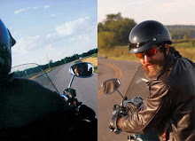
Maintaining mental acuity is as important as physical ability in staying safe on two wheels. My creed on a motorcycle is that in the event of an accident it doesn’t make any difference who is to blame. The rider will still pay the price. What this means to me is that I have to take responsibility not only for my own driving but for knowing what every other vehicle on the road is doing as well. One strategy I use is just accepting that I am invisible. I don’t assume that the other drivers will see me.
This adds considerable vigilance to the process and a corresponding level of tension as well. It makes it all the more important that at the end of the day one can let down completely and relax. A clean motel with an adjacent restaurant goes a long way towards eradicating “road buzz”.
Road Buzz is not a metaphor. One of the things I noticed on my first long motorcycle trip was that the vibration of the bike permeated my body to the bone. I can especially notice this in the hands right away but more interesting is how when I laid down to go to sleep after a long day of riding it was just as I was drifting off to sleep that I would be awakened by a rush of sensation. The frequency was so intense and abrupt that it reminded me of an electrical shock. This sensation is in some way, like an echo of the days travel and juxtaposed with the deep relaxation of falling asleep can be pretty dramatic.
My first bike was a 1979 Sazuki 500 which could shake rattle and roll. The newer 750’s I have ridden are not nearly as assaulting. Still, I noticed lots of nights on this trip that familiar sensation of being shaken back to wakefulness by a rush of vibration.
With a good night’s sleep behind me I spent the morning kicking back and enjoying the pool. I felt only a little guilty. I also made sure we were packed and ready for Paul’s return. By noon we were on the road.
Back tracking north we were in Whitesboro in a little over an hour. West of Whitesboro is a marker for Diamond Horse Ranch and a reference to the
Butterfield. N33° 39.349' W96° 56.208' Diamond Station. Proprietor, John R. Diamond.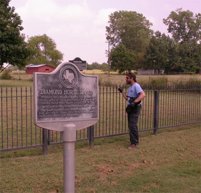
The plaque reads Diamond Horse Ranch
founded 1850 by James R. and John Diamond. Joined later by their brother George, who had founded paper that
today is
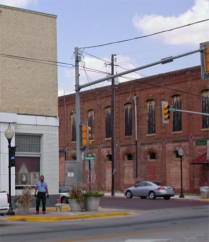
Continuing down Highway 83 we pulled into the square at
was a listed stop and the town is rich with Confederate history and a beautiful Courthouse.

I had purchased the book “900 Hundred Miles on the Butterfield Trail by A.C. Greene. His book was extremely useful in mapping the route through
The Great Hanging was the result of several years of building tension. The completion of the Butterfield Overland Mail route from
It was this same advocacy which was to eventually bring an end to the Great Butterfield
Overland Mail run as well. On March 2, 1861 "Rather than have the Overland Mail Co.'s property fall into Rebel hands, the Postmaster General ordered the Overland Mail to discontinue service immediately and move all the coaches, livestock and equipment north to the
worked for.
The Confederates managed to seize all the Butterfield stations, coaches and livestock in
There are monuments in virtually every
Sitting on a bench by the Gainesville Courthouse near this confederate monument it was a little too easy to feel the past. We located the a plaque commemorating the Butterfield and took this picture of the site of the station at
Back on the bikes we headed southwest to Hood on a
great ride through rolling hills on nice asphalt. We found what we believed to be the Next Station as described by Greene.
Davidson Station, N33° 30.705' W97° 22.988' Run by Dr. J.F. Davidson.
Between Williams and Wheat Creek just west of 373 and just before hitting 922 we found this
jewel at the edge of the pasture.

Those are gun shot holes all over it. What a pity.
Moving on we had black top through Forestburg where there was supposed to be a marker.
Somehow we missed it. I don’t think Forestburg stood out.
Connelly’s Station had some pretty specific locators in Greene’s book but I couldn’t make them work with known locations. We opted for black top to Alvord. The location of Connelly’s is said to be just inside
Ormsby makes a rather comic description of his meal here.
“Our arrival was unexpected, and there was some bustle in getting both breakfast and the team ready. The breakfast was served on the bottom of a candle box, and such as sat down were perched on inverted pails or nature’s chair. There were no plates and but four tin cups for the coffee, which was served without milk or sugar. As there was six of us, including drivers and workmen, those not lucky enough to get a first cup had to wait for the second table. The edible- for there was but the one- consisted of a kind of short cake, baked on the coals, each man
breaking of his “chunk” and plastering on butter with his pocket knife; but butter is a rare
luxury between the Red River and the Rio Grande- at least on this route at present-though doubtless it will be plenty when the line gets in running order so as to convey supplies to the stations. Such, nevertheless, was our meal here, and we were advised by the host to “hurry up before the chickens eat it”- which we did to no little discomfort of the chickens. It tasted good to me, and I can assure you that it would doubtless taste as well to any one coming over the same route at the same speed.”
We Crossed Denton creek about 2.5 miles up stream on highway 1655.
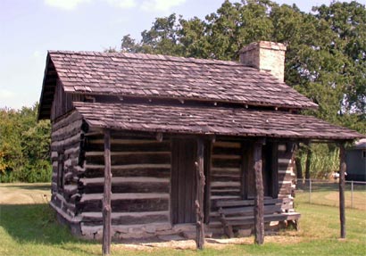
In Alvord we found this cool log cabin reconstruction and made our way towards Erhardt’s Station via 1810.
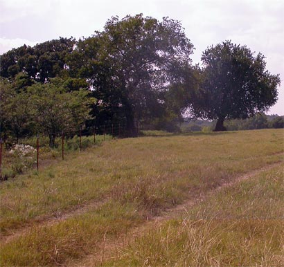
Black top to Earhert’s Big Creek location. 200 yards west of the Wise-Jack county line on the west bank of Big Creek in a location called Hog-eye Prairie was pretty specific. No notable
structures or ruins for Erhardt’s Station N33° 18.674'W97° 55.306'
This is a view of the location:

An interesting note about the Earhert’s Station is that Earhert’s daughter was such a beauty she was known as the Rose of Texas and Queen of the Prairie.
Continuing on we took an unimproved road south just passed Cundiff which closely approximated the trail. Crossing the Trinity it was hard to imagine that at times they had to ford the flooded west fork of the Trinity on a log while the horses and wagon “swam for it”. We wound our way into Jacksboro.
Jacksboro Station (
We made our way into town and were grateful to find a room because it was a big dove hunting weekend and we were lucky to snag the last accommodation.
posted by Don and Paul Matt at 2:46 PM
0 comments
![]()